

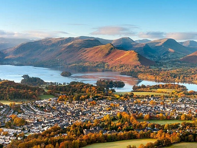
THE CUMBRIA WAY ROUTE
The Cumbria Way Route Summary
The Cumbria Way route is most commonly walked South to North, starting in Ulveston and finishing in Carlisle. It is most often split into 5 roughly equal stages, but can be extended, with a stopover in Rosthwaite, to 6 days.
Suggested 5 day Itinerary
The most popular way to walk the Cumbria Way
| Day | Stage | Approx. Miles | Approx. Km | Approx. Hours |
|---|---|---|---|---|
| 1 | Ulverston to Coniston | 15 | 24 | 7 hours |
| 2 | Coniston to Langdale | 12 | 18 | 5 hours |
| 3 | Great Langdale to Keswick | 15 | 24 | 8 hours |
| 4 | Keswick to Caldbeck | 15 | 23 | 8 hours |
| 5 | Caldbeck to Carlisle | 15 | 23 | 7 hours |
Day 1: Ulverston to Coniston

Distance: 15 miles / 24 km (approx)
Ascent: 615 metres / 2020 ft (approx)
Today’s path & route: Departing The Gill, the start of the Cumbria Way the early part of the day crosses farmland and low level paths. As the route enters the National Park for the first time, soon Coniston Water becomes visible and so does the village of Coniston and Coniston Old Man. Walking along the lake shore, the skyline fills with views of the mountains ahead, with Grizedale Forest to the East.
Refreshments: Torver has a shop, and then Coniston offers enough choice to prepare for the following day. Try the Coniston Foodhouse where you can stock up on snacks, fresh sandwiches and packed lunches.
Ordnance Survey (OS) Map Reference: OL6 South Western.
Day 2: Coniston to Great Langdale
Distance: 12 miles / 18 km (approx)
Ascent: 550 metres / 1800 ft (approx)
Today’s path & route: The day starts with a gentle climb out of Coniston. Mostly low wooded hills with low fell and lakeside paths. Pass through Colwith and Skelwith Bridge, and then the simply stunning Great Langdale Valley starts to appear before you.
Refreshments: Café at Skelwith Bridge, Elterwater and Chapel Stile. The latter offers a village store.
Ordnance Survey (OS) Map Reference:OL6 South Western & OL7 South Eastern.

Day 3: Great Langdale to Keswick
Distance: 15 miles / 24 km (approx)
Ascent: 650 metres / 2,150 ft (approx)
Today’s path: Moderately flat walking from Dungeon Ghyll through Mickleden before a challenging climb over Stake Pass and then dropping into Langstrath Valley. Once Borrowdale Valley opens up ahead, it is a reasonably relaxed walk along the shore of Derwent Water towards Keswick.
Refreshments: There are cafes in Rosthwaite, Grange and Portinscale. Once you reach Keswick you will find several Supermarkets and an array of Cafes and Bars.
Ordnance Survey (OS) Map Reference: OL4 North western & OL6 South Western.
Day 4: Keswick to Caldbeck
Distance: 15 miles / 23 km (approx)
Ascent: 900 metres / 2,950 ft (approx)
Today’s path: Leaving Keswick you follow a fairly steep path up towards Latrigg where you will reach Skiddaw car park. Eventually you will head up the Glenderaterra valley which splits Skiddaw and Blencathra Fells. Beyond Skiddaw House, you will have the option of taking the High Level Route or Low Level Route. Be aware of the weather conditions and choose wisely. The High-Level Route takes in the highest point of The Cumbria Way: High Pike at 658m. 2159ft.
Refreshments: Nothing between Keswick and Caldbeck. Stock up in Keswick
Ordnance Survey (OS) Map Reference:OL4 North Western & OL5 North Eastern.

Day 5: Caldbeck to Carlisle

Distance: 15.5 miles / 25 km (approx)
Ascent: 190 metres / 620 ft (approx)
Today’s path: Today we say goodbye to The Lake District National Park and the majestic mountains within. The trail soon picks up the River Caldew and its more or less by your side all the way to Carlisle. This is fast, gentle and pleasant walking along well graded paths and prepared cycleways.
Refreshments: Caldbeck has a small shop, and Dalston offers a mini supermarket and other independent shops and cafes.
Ordnance Survey (OS) Map Reference: OL5 North Eastern.
6 Day Itinerary
A more sedate journey over 6 days
If you want to extend the Cumbria Way walk, this six day itinerary takes in stops at Rosthwaite.
| Day | Stage | Approx. Miles | Approx. Km | Approx. Hours |
|---|---|---|---|---|
| 1 | Ulverston to Coniston | 15 | 24 | 7 hours |
| 2 | Coniston to Langdale | 12 | 18 | 5 hours |
| 3 | Great Langdale to Rosthwaite | 7 | 11 | 5 hours |
| 4 | Rosthwaite to Keswick | 8 | 13 | 4 hours |
| 5 | Keswick to Caldbeck | 15 | 23 | 8 hours |
| 6 | Caldbeck to Carlisle | 15 | 23 | 7 hours |
More Information
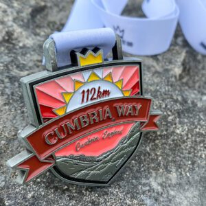
Completed the Cumbria Way Route?
Celebrate completing the 112km Cumbria Way Route with this unique medal from Cumbrian business You’ve Earned It. £1 from every order is donated directly to Mountain Rescue, and you’ll have a permanent reminder of your amazing achievement. Use promo code LakesBaggage10 to receive a 10% discount.
Route Information
Whilst we will endeavour to keep this website up to date with latest news of any Cumbria Way Route diversions or closures, do please check the local Rambler’s Association page as well.
There is currently a route closure in place between Dalston and Cummersdale. You can find out more about this in the news post from Dalston Parish Council. Cumberland Council have indicated the Caldew Cycleway will be closed to pedestrians and cyclists from 19th June 2023 to allow works to be carried out in connection with the construction of the new Carlisle Southern Relief Link (CSRL) and will be in force for 6 months. It is possible the closure may be extended beyond these timelines. (Updated: 19/06/23)
From Dalston it is possible to take the train to Carlisle . Details can be found at National Rail Enquiries. Journey time is usually less than 15 minutes. Check in advance that the trains are running on the required date.

Disclaimer and further assistance
Route information, maps, distances, and itineraries are for general information only and should not be relied on for navigation. It is your responsibility to check your route and to ensure you have the correct level of skills and experience to undertake the Cumbria Way route.
Hill walking and participating in other outdoor activities carries with it a danger of personal injury or death. You must be aware of and accept these risks and be responsible for your own actions.
For more information on how to prepare and plan for your Cumbria Way walk, please refer to our planning guide